
Trippin’ in the Sierra
It was a gorgeous late-spring morning this past Monday when I drove into the Sierra to join fellow members of the North Fork History Group on another one of our field trips.
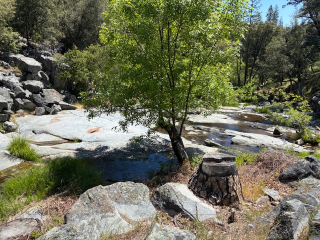
This time, our destination was John Blossom’s 50-plus acre mountain spread a few miles above North Fork. John and his wife bought the place and moved up from Fresno about four decades ago.
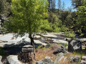 They were first attracted by the beauty of their heavily forested land (right). And then they started discovering the historical sites on it. It was a couple of those sites that the dozen-or-so History Group members had gathered to see.
Our guide — Connie Popelish, who served for decades as archeologist for the Sierra National Forest — showed us remnants of a ditch that had been started sometime in the 1880’s to bring water from Willow Creek in Crane Valley (which is now covered by Bass Lake) to the mining community of Narbo.
There’s nothing left of Narbo now because that ditch never got water, and Narbo died away.
But during its brief existence, it was said to boast a population of about 1,500 — though that figure, like so many other population totals given for old-time mining communities in this part of eastern Madera County — is suspect.
Narbo was founded by French investors, one of whose names was said to be Narbonne (depending on whose history you read). Those investors built a 24-room mansion — called “the house of glass” — on Narbo’s highest peak.
That mansion was said to have had dozens of windows which — when the sun was setting — blazed like a great fire. Night lights from the mansion were said to be visible for miles.
The view from a glass tower on the mansion was said to be magnificent. Furnishings inside included silver, china and fine linen from overseas. The bedrooms all had imported linens, and each bedroom had a small fireplace.
Two French chefs prepared foods for distinguished foreign visitors who dropped by. You get the idea. It was outlandish opulence built on a hope and a prayer — that of striking it rich in the mines.
Narbo briefly had its own post office — which many of the mining towns did. A big mill was being built to crush the gold-bearing quartz being dug from veins in the area.
But it all went south when the mighty Miller and Lux land interests — which controlled hundreds of thousands of acres in the mountains and in the San Joaquin Valley and — more importantly, the water rights to that acreage — denied Narbo’s proprietors the right to any of the water the ditch would have carried.
So Narbo perished, and eventually, that mighty mansion on the hill burned to the ground.
With that as background, Connie showed us remnants of that ditch, which happened to be on John Blossom’s land. Springtime grass obscured the ditch bottom, but Connie pointed out low spots where she had followed the ditch path years earlier.
In fact, she was the first to have mapped much of that path.
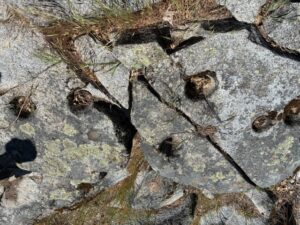 Then Connie led us down another path — this one to mortar holes, or cups, (left) along Little Fine Gold Creek on Blossom’s property. Native Americans had created these cups in the granite along the creek many, many years ago. They used pestles to pound acorns, which were part of their diets.
I had seen mortar cups in granite just below the Manzanita Lake dam a few miles away, but I had never counted the number of cups.
And it’s that number that Connie told us was most important.
She said that — in her decades-long research and conversations with Native Americans — she learned that a mortar cup site that had at least 14 holes was a “key site.”
And within a circular radius of a mile around each of these key sites were other, much smaller mortar hole locations with far fewer holes, or cups.
She said that type of “construction” — a key site with 14 (or so) holes and surrounding “satellite” sites with fewer holes — was common among Native American tribes.
Our History Group had never heard that.
After we’d been “wowed,” we all digested that information, along with a tasty potluck lunch, at John’s place. He provided a ton of fried chicken, Connie made her famous potato salad, others brought veggie dips, and I straggled along by bringing Costo cookies.
It was a great way to cap off this particular educational outing.
A few weeks earlier, we had all trekked up (on another gorgeous Monday morning) to a once-thriving small community along the upper reaches of the San Joaquin River in the Sierra.
We went to see the remains of the settlement of Chawanakee — which had been built for the families of workers who constructed and operated one phase of the absolutely gigantic Big Creek Hydroelectric Project. That project began in 1911, and construction continued for decades.
The entire shebang is now owned by Southern California Edison and was built to provide electric power to Los Angeles. John Eastwood designed much of it, and it was funded by Henry Huntington’s Pacific Light and Power Company. It was said to be the biggest hydroelectric project in the world. It now generates about 4 billion kilowatt hours a year — 12 percent of all the hydroelectric power in California.
And, yes, Huntington Lake — at 7,000 feet, a beloved destination for folks escaping the scorching summer heat of the San Joaquin Valley — is named for Henry Huntington.
The project consists of numerous reservoirs and more than two dozen dams and generating units in nine powerhouses. Chawanakee was at Powerhouse Number Three — built in 1923 — on the San Joaquin River.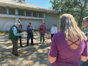
Chawanakee once had between 30 and 45 homes for workers and their families, along with a school with grades one through eight. No houses are left, but one of the school buildings remains (right).
Until 2020, another building from the school stood alongside the one we visited. But that building burned in the devastating Creek fire that scorched nearly 400,000 acres. Somehow, that fire burned down a mountain, destroyed one of the school buildings but left the other, beside it, intact.
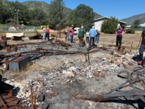 We walked through the ruins of the one school building (left) and wondered about the immense power — and complete unpredictability — of Sierra wildfires.
Charles Richie — our guide that Monday morning — had attended Chawanakee School decades earlier, and his tales of school and community social life were priceless. He recalled Friday nights being “movie night” in Chawanakee, with those flicks being screened in the school’s gym. He said he spent his summer vacations hiking the Sierra.
And he recalled his family driving to Fresno once a month for groceries.
It was a fascinating look at mountain life from more than a half-century ago.
After our brief stay in Chawanakee, our group motored down to the Wishon Powerhouse on the San Joaquin River. Kerckhoff Dam and Powerhouse No. 1 were built in 1920 and are part of Pacific Gas and Electric’s Kerckhoff Hydroelectric Project. Yes, the two giant utilities — SoCal Edison and PG&E — have built hydroelectric plants on the same river, just miles apart.
The San Joaquin River is mighty, indeed.
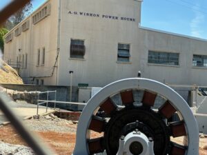 I know nothing about hydroelectric projects, of course. But what I saw, both at Chawanakee and at Kerckhoff, were engineering marvels that it’s almost impossible to believe were constructed well before any modern equipment was available to help the builders.
Workers somehow, some way, bore through mountains, created giant tunnel after tunnel, risked their lives building power plants and dams — and created a hydroelectric system that provides water for much of California to this day.
And that, my friends, is amazing to me. Those workers were giants, indeed.
Yes, this “flatlander” learned a whole lot on my past two treks into the Sierra — as I have done every time I’ve been fortunate enough to join the History Group on a mountain trip. We not only get to experience lovely spring or summer or fall weather — depending on when we go — we get to learn more than school ever taught us about the fascinating history of this mountainous part of eastern Madera County
That’s what I call a win-win.